Equestrian Trails and Campgrounds

Category: Texas Trails (Page 5 of 11)

Hi View Ranch, Midlothian TX


Hi View Ranch Equestrian Trails

Review and photos provided by Amy Hesselgesser, thank you Amy!

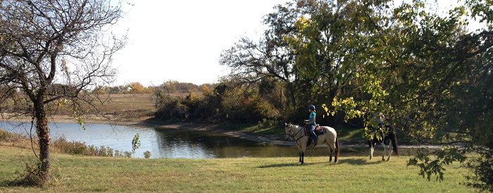
Hi View Ranch has now opened several miles of equestrian trails for bring your own horse trail riding!

Photo provided by Amy Hesselgesser.

Website:

Trail Marker

Contact: Ranch Director Casey Bilbrey, 214-564-5573.

Email:Casey_Bilbrey@uss.salvationarmy.org

Address:420 E. FM 875, Midlothian, TX 76065

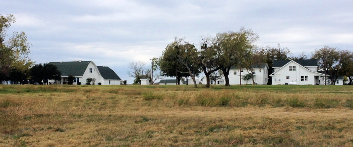
Directions: The ranch is located in Midlothian and is about 45 min south of Dallas. Take HWY 287 to Midlothian and exit at FM 663.  Head south on FM 663 about 5 miles  to  where the road ends at the stop sign for FM 875.  At the stop sign turn left.  You will see the white buildings of the ranch immediately on your right.  Take the second gate into the field east of the white houses and park your trailers there.

Fees:
10$ per horse per day.  Riders must fill out a waiver and contact Casey to make an appointment to ride.  Ranch is open 7 days a week for riding.
Trailhead :
Trailhead is in a large open field east of the ranch homes with plenty of room to maneuver your big rigs.

Terrain:
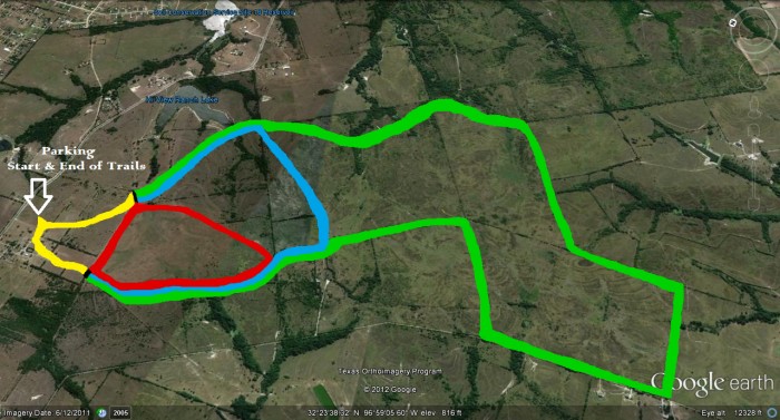
The terrain is open pasture with rolling hills and trees with a few rocky areas. Shoes are not necessary.  There is a small lake on the east side of the blue/green trail.

Mileage: Unknown at this time, however, Casey will be sending in this information soon. The trails are color coded; green, blue, red, and yellow.

Trail Map:

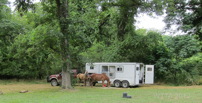
Facilities:Overnight camping with your horses is allowed. The camp ground area is primitive (no hook ups or pens) but generators are allowed. You can tie your horse to the trailer, bring your own pen, or picket them. The campground is by the lake and also has volley ball courts, picnic tables, and you can fish at the lake. The Ranch also has rooms available to rent.

Dogs: Dogs are allowed and can even be off lease so long as they are friendly and don’t cause mischief.

From the Parking Pasture next to the trail head, the white houses are Hy View Ranch.

Green Trail

Description: Hi View Ranch is a Christian based facility and working Guest Ranch where you, your family and friends can enjoy a variety of activities such as Horseback Riding, Fishing, Hiking Tennis, Horse Shoes, Volleyball, Walking Trails, Picnic Areas, Camping, Bird Watching, Campfires and more.  The ranch has now opened several miles of equestrian trails for bring your own horse trail riding. There is over 2500 acres of excellent trails, which provide a real open range feel!
Caddo Wildlife Refuge, Karnack TX


Contributor: NETASA – Northeast Texas & Surrounding Areas, American Indian Horse riding club

Caddo Lake National Wildlife Refuge – WK Stephenson M.D. Equestrian Trail

Website: Be sure to review the site for park rules and additional informaiton.
Trails info Link:  http://www.caddofriends.org/wildlifetrails.asp
Home site: http://www.caddofriends.org/

Location:
Karnack, Harrison County, TX
GPS Coordinates: 32.66795, -94.16782

Contact: Phone Number:
903-679-9144

E-mail:
Mark_Williams@fws.gov

Directions:
From Dallas (2 hours): take I-20 east to Marshall, TX, and get on Hwy. 59 North. Go through town to HWY. 43 North; take 43 North. In ten minutes or so, you will come up on 449 spur. Take a right on 449 (also a post office sign on Hwy. 43). Follow this for about 2 or 3 miles, and you will come to the intersection of 43 and Hwy. 134. There will be a post office on the opposite right corner and the Karnack Community Center on the opposite left corner. Go straight through the intersection and over the train tracks, and you will enter the refuge.

From Shreveport (1/2 to 3/4 hour) – Take I-20 West to Waskom, TX. At David Beard’s Catfish Restaurant, take Hwy. 134 North out of Waskom. Follow Hwy. 134 into Karnack. In Karnack, you will come to the intersection of Hwy. 134 and 43 (T.J. Taylor Avenue). Take a right past the post office and cross the train tracks, and you will enter the refuge.

Camping:There is no overnight camping.

Hours: Open from sun up to sun down.


Continue reading

Alamo River RV Resort, Von Ormy TX

Alamo River RV Resort in Von Ormy, TX just south of San Antonio

(See trail description below provided by Deb Demers, thanks Deb for your most recent update detailing that as of Oct. 2016 most of the adjoining property is no longer accessible via horseback currently – hopefully that will change)


Lower Campground at Alamo River RV Resort

Riding along the Medina, image provided by Deb Demers.

Website:
http://www.alamoriver.com/
Facebook Page – http://www.facebook.com/alamoriver

Location: 12430 Trawalter Lane, Von Ormy, TX 78073

Latitude: 29 17′ 57″ N
Longitude:98 39′ 11″ W

Directions:
From the North or East: Take I-35 south (toward Laredo) to exit 140, Loop 1604. Turn Right onto Loop 1604 and drive 2/10 mile then turn Left onto Quintana access road. Drive 2/10 mile, cross RR tracks and make an immediate right turn onto Quintana Road. Drive 9/10 mile to first road on left, Trawalter Lane. Make left turn onto Trawalter Lane. Drive 7/10 mile and Alamo River RV Ranch is on your right at the end of Trawalter Lane.

From the West: Take I-35 East to Exit 140, At end of off ramp turn left onto Loop 1604 and drive 3/10 mile then turn Left onto Quintana access road. Drive 2/10 mile, cross RR tracks and make an immediate right turn onto Quintana Road. Drive 9/10 mile to first road on left, Trawalter Lane. Make left turn onto Trawalter Lane. Drive 7/10 mile and Alamo River RV Ranch is on your right at the end of Trawalter Lane.

From the North on Loop 1604: Proceed South on 1604 to 4-Way Stop sign at Old Pearsall Road. Go straight ahead 1 mile and turn right on Quintana Access Road and then an immediate left onto the Access Road. Drive 2/10 mile to next intersection and turn left onto Quintana Road. (Do NOT cross RR tracks). Drive 9/10 mile to first road on left, Trawalter Lane. Make left turn onto Trawalter Lane. Drive 7/10 mile and Alamo River RV Ranch is on your right at the end of Trawalter Lane.

View of the Medina River from the trail. Provided by Deb Demer.

Contact:
1-800-RV-Resort or 1-210-622-5022

Email:
info@alamoriver.com

Camping: Overnight camping with your horse is allowed!  Horse camping is allowed on the lower campground which is located at the back of the park.  Once you drive to the back of the park you take a right and head down hill on a cement driveway.  This area of the park is beautiful, lined with large oaks and pecan trees, and it is just off of the Medina River.  There is no lack of shade in this section of the park. The upper campground normally does not allow horse camping.

Cost: $10 for day riding. The rates on top with full hook up (30/50 amp, water and sewer) are $39 per
night and the rate for the full hookup sites down below (at the bottom of the concrete drive) are $45 per night.  Water only hookups on the lower campground are $25. All of these include Free WiFi.Rates may change over time so always call before you haul.

Cabin: The park also has a Bedroom Cottage which is $50 per night during the week and $65 per night on the weekend.

Hours: Day use  hours are 8am until sunset.  If you are tent camping you are asked to be out of the park by sunset on the date of your departure.

Cell Phone Coverage: Cell phone service is very consistent in the park and on the trails.  You can get 4G depending on the carrier but 3G and 2G is very reliable.

Dogs: Dogs are allowed but must be on leash at all times and not left unattended. The park asks that you please pick up after your dog. Dogs are not allowed on the trail with horses but you can walk them on leash.

Continue reading

Muleshoe Bend, Spicewood TX

Muleshoe Bend Recreation Area – Lake Travis


Carol Grosvenor on Bug.

Contact: LCRA (Lower Colorado River Authority)

Honor Box Payment System

(512) 473-3366 or
(800) 776-LCRA, Ext. 3366

Location: Spicewood, TX – close to Marble Falls and Northwest of Austin

Address:
2820 County Rd. 414
Spicewood, TX 78669

Coordinates: 30.486976,-98.098566 (+30° 29′ 13.11″, -98° 5′ 54.84″)

Google Map Link


Directions: From Texas 71 turn east (right if you are going north from Austin or Left if you are heading south coming from Marble Falls) on Co. Rd. 413/Greg Dr.  which turns into Co. Rd. 404/Haynie Flat Rd. Turn left on Co. Rd. 414, this road will turn right and you will pass Hollingsworth Rd. and Exeter Rd. on the right.  Stay on Co. Rd. 414 as it will go directly into Muleshoe Bend.


Camping: Camping with horses is allowed!

Cost: Day Riding: $5.00 and Primitive Camping: $10.00

Facilities: When entering Muleshoe Bend there is a nice female/male bathroom facility to the left which also has an outdoor shower, water fountains, rock benches under an awning, and a water faucet which you can hook a hose to and fill your water buckets.  The rest of the park is primitive with no running water and a few chemical toilets.  There is no designated equestrian trailhead.  You can park at any of the camping areas or in the grass with your truck and trailer.  Some of the campsites have picnic tables.

Dog: Dogs are allowed but are required to stay on leash.

Hunting: Not Allowed

Mileage: Unknown

Continue reading

Lake Bardwell, Ennis TX

Contributor: Amy Hesselgesser (Thank You Amy!)

Waxahachie Creek Park at Lake Bardwell

The Red Trail at Waxahachie Creek Park at Lake Bardwell.


Website for Information:

http://www.swf-wc.usace.army.mil/bardwell/Recreation/Trails/Horse.asp

Contact:

Lake Bardwell COE Phone:

(972) 875-5711 or for reservations call (877) 444-6777

Address:

930 Bozek Rd., Ennis, TX 75119

GPS coordinates:  N32º17.773′ & W096º41.794′

Directions to Waxahachie Creek Park

To Waxahachie Creek Park, from Dallas head south on I-45 towards Houston.  Head 36.4 miles to exit 247, US-287 North/Congressman Joe Barton Parkway towards Waxahachie/ Ft.Worth.   Head North 4.1 miles to Kaufman/Italy exit that leads to intersection of Texas State Highway 34.  Turn Left on Highway 34 heading southwest 2.9 miles to Bozek Rd.  Turn right on Bozek Road.  Park is 1.5  miles at the end of Bozek road.

Overnight Equestrian Camping:

Allowed, fees listed on COE website

Cost:

The day riding fee is listed as $3.00

Facilities:

Multiple covered 10×10 pens at trail head, water and electric available, mounting ramp, level parking with multiple grassy sites for saddling your horse.  Hitching posts at trail head.


Horseshoe Bend bridge on the Blue Trail.

Mileage:

Just over 13 miles of one way trails, making a round trip of approximately 27 miles.

Terrain:

The Terrain is easy and does not require you to have shoes/boots for your horse. It is mostly flat with some hilly terrain on the offshoot trails. I was told there is water access at the head of the pink trail but we did not make it to that point.

Map:


Continue reading

« Older posts Newer posts »